NaVIC: All you need to know
NaVIC is an acronym for Navigation with Indian Constellation which is a navigation system built up by ISRO (Indian Space Research Organization). In sanskrit it is also meant as "a sailor".Many people may have heard about IRNSS (Indian Regional Navigation Satellite System), which is now officially called as NaVIC. It is an independent navigation satellite system made by India.
Today there are various navigation satellite systems made by different countries. For example, US has GPS (Global Positioning System), Russia has GLONASS (GLObal NAvigation Satellite System), European Union has Galileo, China has BeiDou and Japan has QZSS (Quasi-Zenith Satellite System). Many countries have already built up their own navigation system for better security. That is why India also built up its own navigation system IRNSS which is now officially called as NaVIC.
History:
Before discussing brief of it, let us discuss a little bit of its history. Mostly we use GPS for tracking locations in daily life. But this GPS is owned by US and in some serious situations they might not provide their facility to others. In 1999, during Kargil War, Indian military needed GPS for tracking of Pakistani troops, but the response from US was not good. India learnt a big lesson from that incident which forced them to think of an independent navigation system. Thus, in May 2006, the Indian government approved the IRNSS project.
Development of NaVIC:
IRNSS-1A:
 |
| Fig: Image of IRNSS-1A satellite (Image credit ISRO) |
In July 1, 2013, first launch was initiated of the satellite IRNSS-1A carried by PSLV-C22 launch vehicle. IRNSS-1A carried two types of payloads; one is the Navigation payload and other one is the Ranging payload.
Navigation Payload:
It transmits navigation service to the users. This payload operates in L5-band and S-band. It consists of a highly accurate Rubidium atomic clock. (L5 band has frequency of 1176.45 MHz and S band has frequency range of 2-4 GHz).
Ranging Payload:
It consists of a C-band (range is 4-8 GHz) transponder which determines the accurate range of the satellite. The IRNSS-1A also carried Corner Cube Retroreflectors for laser ranging.
The physical dimension of the satellite was 1.58 meter X 1.50 meter X 1.50 meter. The lift off mass was 1425 kg with propulsion 440 Newton Liquid Apogee Motor (LAM) and twelve 22 Newton thrusters. The satellite was powered by two solar panels generating 1660 Watt and one lithium ion battery of 90 Ampere-Hour capacity.
IRNSS-1B:
 |
| Fig: Image of IRNSS-1B (Image credit ISRO) |
IRNSS-1B was the second navigation satellite of the IRNSS space segment. It was launched on April 4, 2014 through PSLV-C24 launch vehicle. The payloads were same as the previous IRNSS-1A satellite. The lift off mass of the satellite was 1432 kg. However, the rest of the physical parameters like dimension, apogee motor, thrusters, power section were all same as IRNSS-1A.
IRNSS-1C:
 |
| Fig: Image of IRNSS-1C (Image credit ISRO) |
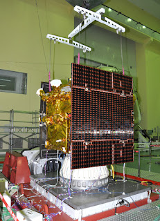
IRNSS-1C was the third navigation satellite of the IRNSS space segment. It was launched on October 16, 2014 through PSLV-C26 launch vehicle. The payloads were also same as the previous satellites. The lift off mass of the IRNSS-1C was 1425.4 kg. However, the rest of the physical parameters like dimension, apogee motor, thrusters, power section all were same as the previous satellites.
IRNSS-1D:
 |
| Fig: Image of IRNSS-1D (Image credit ISRO) |
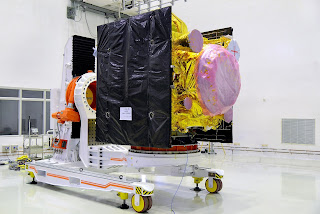
IRNSS-1D was the fourth navigation satellite of the IRNSS space segment. It was launched on March 28, 2015 through PSLV-C27 launch vehicle. The lift off mass of the satellite was 1425 kg. Unlike the other satellites, IRNSS-1D was launched in a sub Geosynchronous Transfer Orbit (other satellites were launched in Geosynchronous Transfer Orbit). The power section contained Ultra triple junction solar cells which generated 1660 watt of electrical power. For providing reference for the satellite, star sensors and gyroscopes had been used. Special thermal control schemes had been designed for elements of atomic clock. The propulsion system was consisted of Liquid Apogee Motor (LAM) and thrusters.
IRNSS-1E:
 |
| Fig: Image of IRNSS-1E (Image Credit ISRO) |
IRNSS-1E was the fifth navigation satellite of the IRNSS space segment. It was launched on January 20, 2016 through PSLV-C31 launch vehicle. The lift off mass of the satellite was 1425 kg. The configuration of the satellite was similar to that of the previously launched satellites.
IRNSS-1F:
 |
| Fig: Image of IRNSS-1F (Image credit ISRO) |
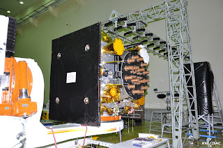
IRNSS-1F was the sixth navigation satellite of the IRNSS space segment. It was launched on March 11, 2016 through PSLV-C32 launch vehicle. This satellite was launched to the sub Geosynchronous Transfer Orbit from SDSC (Satish Dhawan Space Centre). The configuration of the satellite was similar to the previously launched satellites.
IRNSS-1G:
 |
| Fig: Image of IRNSS-1G (Image credit ISRO) |
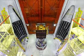
IRNSS-1G was the seventh navigation satellite of the IRNSS space segment. It was launched on April 28, 2016 through PSLV-C33 launch vehicle to the sub Geosynchronous Transfer Orbit. The configuration of the satellite was similar to that of the previously launched satellites.
IRNSS-1H:
 |
| Fig: Image of IRNSS-1H (Image credit ISRO) |
IRNSS-1H was planned to be launched by PSLV-C39 launch vehicle to sub Geosynchronous Transfer Orbit with a 284 km perigee and 20,650 km apogee. But, the mission was unsuccessful and the satellite could not be placed at the orbit.
IRNSS-1I:
 |
| Fig: Image of IRNSS-1I (Image credit ISRO) |
IRNSS-1I was the eighth navigation satellite of the IRNSS space segment. It was launched on April 12, 2018 through PSLV-C41 launch vehicle. This satellite was the replacement of IRNSS-1A, because IRNSS-1A failed due to issue with Rubidium atomic clock. So, IRNSS-1I was launched to complete the whole constellation. The lift off mass of the satellite was 1425 kg. The configuration of the satellite was similar to that of the previously launched satellites.
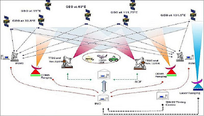
IRNSS Architecture:
- Space Segment
- Ground Segment
- User Segment
Space Segment:
The whole constellation contains 7 satellites. 3 of 7 satellites are in geostationary orbit located at 32.5 degree east, 83 degree east and 131.5 degree east longitude approximately 36,000 km above the surface of the earth. The rest of the four satellites are in inclined geosynchronous orbit. Two of them cross equator 55 degree east and other two at 111.75 degree east.
Ground Segment:
The ground segment is responsible for maintenance and operation of the IRNSS constellation. It consists of:
- ISRO Navigation Centre
- IRNSS Spacecraft Control Facility
- IRNSS Range and Integrity Monitoring Stations
- IRNSS Network Timing Centre
- IRNSS CDMA Ranging Stations
- Laser Ranging Stations
- Data Communication Network
User Segment:
User segment mainly consists of IRNSS receivers. They will be single frequency receiver capable of receiving SPS (Standard Positioning Service) signal at L5 or S band frequency, dual frequency receiver capable of receiving both L5 and S band frequency and receiver compatible with IRNSS and other GNSS (Global Navigation Satellite System) signals.
Accuracy:
The IRNSS constellation will provide an absolute position accuracy of better than 10 meters throughout India and better than 20 meters in the Indian Ocean. In 2017, Satellite Application Centre (SAC) had said that NaVIC will provide SPS to all users with a position accuracy upto 5 meter. Whereas,GPS has the accuracy of 20-30 meter. Unlike US based GPS, NaVIC uses two frequency bands (S and L) (GPS uses only L-band). When low frequency wave travels through the atmosphere, then velocity of the wave decreases due to the atmospheric disturbances. So, they have to use atmospheric model to distinguish the error and also it has to update the model from time to time for the exact error. However, as NaVIC uses dual frequency bands, they just have to calculate the delay between the two signals for determining the error. So, NaVIC do not need any model and hence it is far better and accurate than GPS.
Applications:
Some applications of IRNSS are:
- Terrestrial, Aerial and marine navigation
- Disaster management
- Vehicle tracking and fleet management
- Integration with mobile phones
- Precise Timing
- Mapping and geodetic data capture
- Terrestrial navigation aid for hikers and travellers
- Visual and voice navigation for drivers.
Future Development:
The Department of Space (DOS) has planned to expand the constellation from 7 satellites to 11 satellites to extend the coverage. These four satellites will be launched in the geosynchrounous orbit in an inclination of 42 degree with respect to equator. The next batch of the NaVIC satellites are IRNSS-1J, IRNSS-1K, IRNSS-1L, IRNSS-1M and IRNSS-1N.
Soon, NaVIC will be available in various mobile phones and other electronic devices. The configuration of NaVIC is in both hardware and software level. That means, if NaVIC has not been integrated with chip then it cannot be used whether you have software or not. Qualcomm Technologies, Inc. has developed and tested first ever chipset which supports NaVIC. For the first time ever, this regional navigation system will be available in Snapdragon mobile phones.
This technology will enhance the geolocation capabilities of mobile phones, automotive and IoT (Internet of Things) solutions in this region.
All the best to team ISRO....




0 Comments
Please do not enter any spam link in the comment box..